Enregistrez gratuitement cette image
en 800 pixels pour usage maquette
(click droit, Enregistrer l'image sous...)
|
|
Réf : T02621
Thème :
Terre vue de l'espace - Villes (375 images)
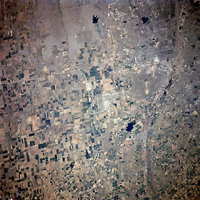
Titre : Denver International Airport, Colorado, USA April 1998
Description : (La description de cette image n'existe qu'en anglais)
Denver International Airport, Colorado, USA April 1998 The multiple runways of the Denver International Airport can be seen in the center of the image. The light colored, linear features that are located south and west of the airport are Interstate Highway 10 (east-west) and Interstate Highway 225 (north-south), respectively. Most of the rural land in the scene of the western High Plains shows a variety of cultivated field patterns of varying sizes, shapes (rectangular), and colors, where irrigation and dry land farming is practiced. The region receives an average 15 inches (38 cm) of precipitation per year, producing a semi arid climate. A few circular fields indicate that the center pivot irrigation technique is being used on a limited basis in the region. Barr Lake, a state park (dark feature northwest of the airport), is located on the Beebe Seep Canal. Immediately west of this feature, the gently curving floodplain of the South Platte River is barely visible as it heads northward. Most of the southwestern quadrant of the picture consists of urban development, as the cities of Denver and Aurora expand eastward. Cherry Creek Lake (dark feature with a smooth-looking shoreline southwest of the airport) is gradually being encircled by urban growth
|
|

